‘Omaha Underground’ by Geoff DeOld
September 7th, 2011 : : Anne : : Tag Words: Banner, Stored Potential 2As the City of Omaha works toward completing a new Transportation Master Plan by the end of 2011, “Omaha Underground” imagines a mass transit alternative to the existing automobile dominated transportation infrastructure shaping much of the Omaha landscape, with an underground metro often found in larger metropolitan areas such as London, Beijing, or New York. The proposed layout of distinct subway lines mimics several of the existing transportation corridors servicing the Omaha area, with an emphasis on providing greater connectivity to the first and second rings of suburbs where existing mass transit opportunities are in greater need.
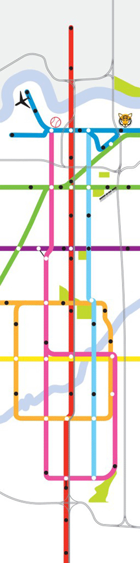
Oriented east-west top to bottom with the Missouri River and Council Bluffs at the top of the map, the graphics are contorted, sublimating proportional accuracy for the sake of fitting the banner format and emphasizing Omaha’s east-west direction of growth. Although a subway system is somewhat of a fantastical transit dream for a city the size of Omaha, the notion addresses edges and peripheries and the WHOLE metro region as an interconnected system, as subways often do.
Red Line – Dodge Street Corridor Stations and Cross Streets: North Main Street (Council Bluffs), North 35th Street (Council Bluffs), 13th Street, Joslyn, Midtown Crossing, UNMC/Saddlecreek Road, 50th Street, Dundee, Memorial Park, 72nd Street, Children’s Hospital, 90th Street, Westroads, 120th Street, 168th Street
Pink Line – Cuming Street Corridor and Loop Stations and Cross Streets: North Downtown, Creighton, Dundee, Western Avenue, Creighton Prep, Blondo Street, Underwood Hills, 96th Street, Westroads, Happy Hollow, Town Park, 84th Street, St. Mary, Crossroads
Cyan Line – Leavenworth / Pacific Line Stations and Cross Streets: 13th/Leavenworth, 36th Street, 42nd Street, 50th Street, 60th Street, Elmwood Park, 84th Street, 90th Street, Happy Hollow Country Club
Blue Line – 13th Street Corridor Stations and Cross Streets: North Omaha, Eppley Airfield, Gallup Campus, North Downtown, 13th Street, Old Market, 13th/Leavenworth, Henry Doorly Zoo
Green Line – Saddle Creek Corridor Stations and Cross Streets: Adams Park, Bemis Park, Creighton Medical Center, Leavenworth, Field Club, MCC
Purple Line – 50th Street Corridor Stations and Cross Streets: NW Radial Hwy, Metcalfe Park, Underwood Avenue, Dodge Street, 50th Street, L Street
Orange Line – Midtown Loop Stations and Cross Streets: Ames Avenue, Western Avenue, Memorial Park, 60th Street, Holy Cross Field, Stinson Park, St. Mary, 84th Street, Country Side Village, West Dodge Road, Underwood Hills, Keystone Drive, North 72nd Street, Benson
Yellow Line – 72nd Street Corridor Stations and Cross Streets: Maple Street, Blondo Street, Crossroads, West Center Road
Geoff DeOld is a partner at DeOld Andersen Architecture (DAA), an architecture and design practice in Brooklyn, NY. He received his Master of Architecture from the University of Nebraska – Lincoln and located to New York City in September of 2001. Prior to forming DAA with partner Emily Andersen, he was an Associate Principal at STUDIOS architecture in New York City where he contributed to several notable and award winning projects.
Geoff formed DAA with Emily Andersen after collaborating together on several projects addressing the suburban landscape and the role architecture and design might play in an otherwise generic environment. The firm is currently engaged in several projects including showrooms and offices for a fashion company in the Fashion District, and two streetscape / urban design projects in the Bedford Stuyvesant community of Brooklyn.