
Shifting Thresholds
Investigating the relationships among people, land, ownership, and development at the suburban/rural edge.
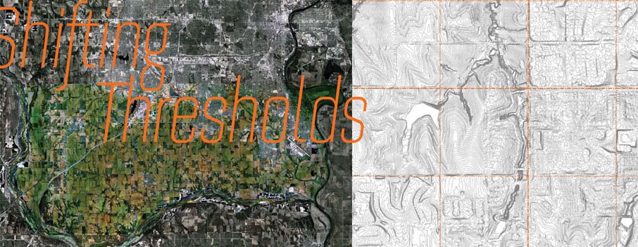
Shifting Thresholds is a multiphase undertaking intended to deepen our understanding of the unique landscapes comprising the suburban/ rural edges in the Great Plains. With few natural boundaries guiding expansion, new forms of settlement respond to a seemingly infinite availability of land and the relentless orthogonal demarcation of the Public Land Survey System of 1785 (Jeffersonian Grid). These boundaries of survey and ownership remain the primary system determining current development patterns and form. The resulting landscapes operate with development and agriculture co-existing in a continually changing patchwork of ownership and use. Often comprising rich soils, natural corridors connecting the city to outlying recreational landscapes, and important logistical networks connecting one city to another, these landscapes hold the key to an innovative future urban form.
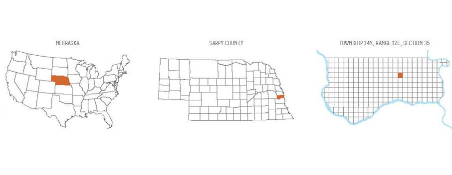
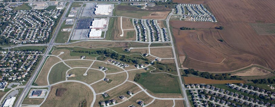
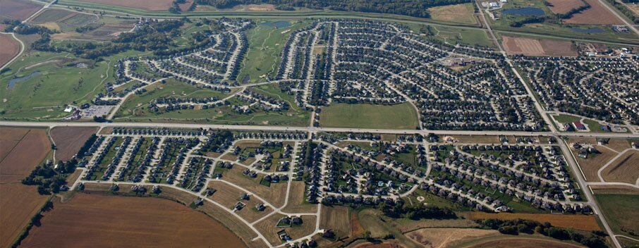
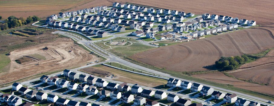
Bordered by the City of Omaha and the Missouri and Platte Rivers on three sides, Sarpy County has faced rapid suburbanization and vastly shifting forms of settlement. Although many family farms have given way to new housing and commercial developments, Sarpy County remains 60% agricultural, containing some of the state’s richest soils; a key piece of the I-80 corridor connecting Omaha to the State Capital in Lincoln; rich river floodplain ecologies; and a unique mixture of agricultural heritage. These factors make it critical in shaping the future of the Omaha metro area. Shifting Thresholds expands the scope of Emerging Terrain’s programming geographically and in scale, focusing on the suburbanization of the Omaha metropolitan area, a condition that resonates nationwide.
Research (2011-2012)
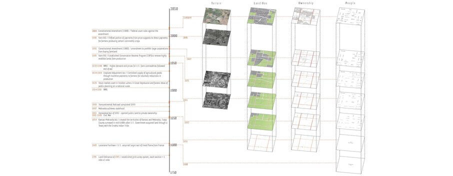
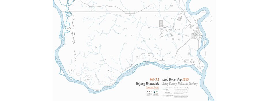
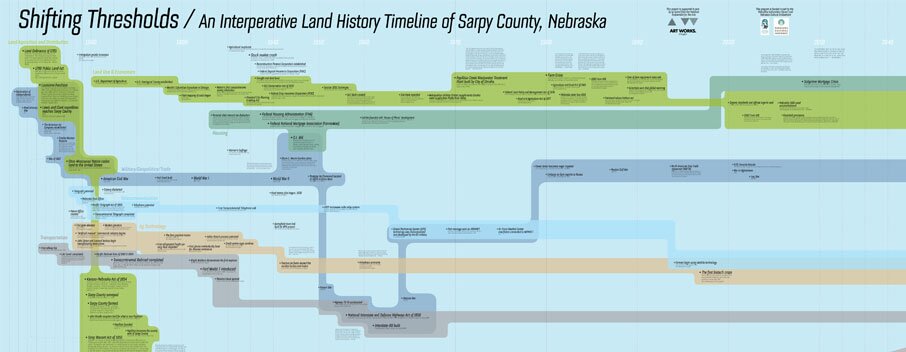
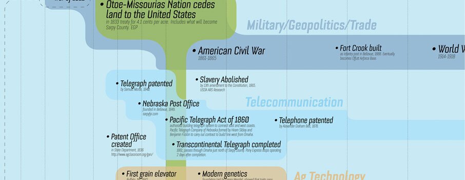
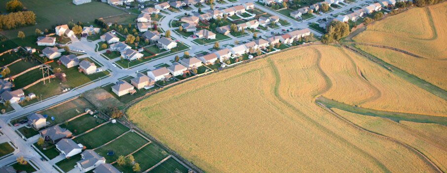
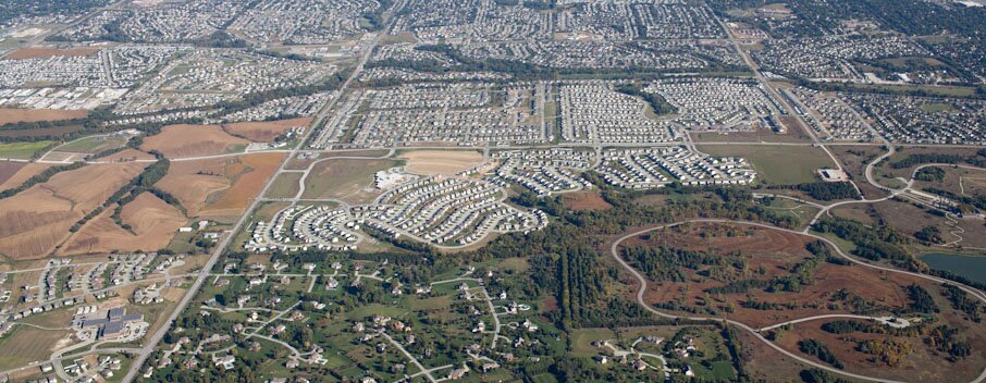
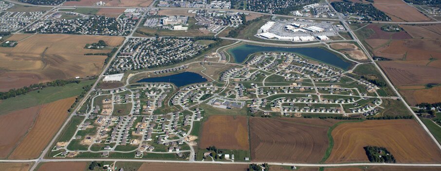
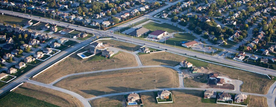
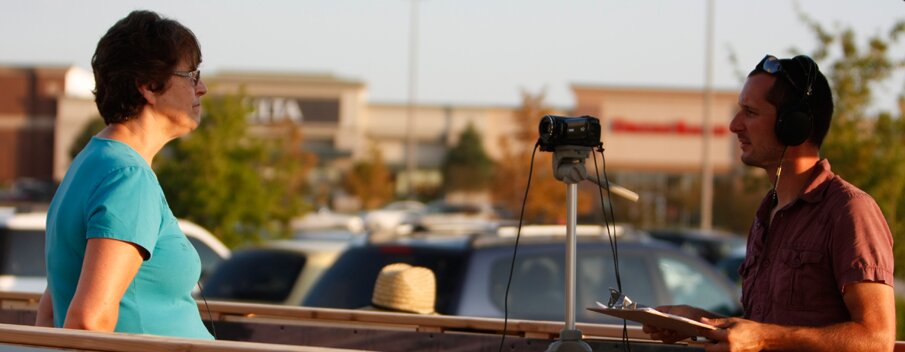
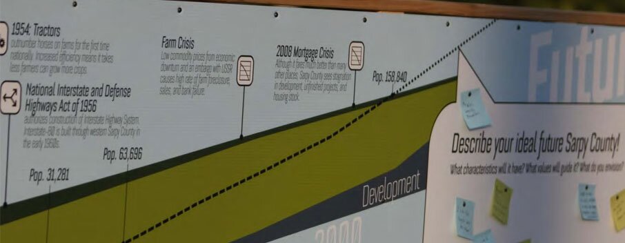
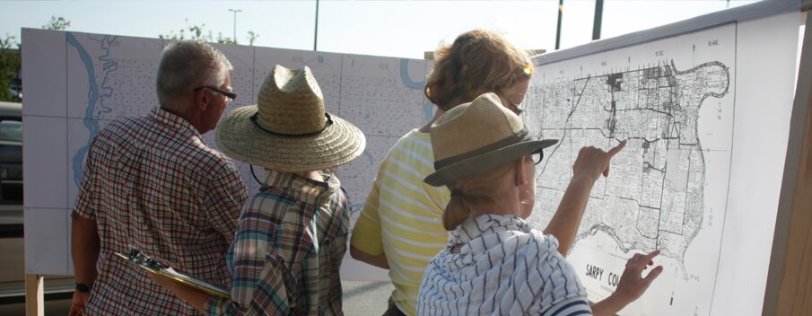
This project has documented and made visible a multi-faceted history: one part physical and another part social through historical and analytical ownership mapping, aerial photography, driving interviews with suburban residents, farmers, and the development community, and a categorical timeline visualizing generational responses to changing tax code, agricultural innovations, and familial circumstances. The recorded interviews provide local perspectives highlighting the nuances of the past and present.
Click the following links to download (documents are very large and will take time to download):
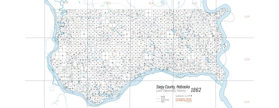
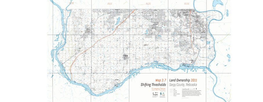
3. Ownership Maps Pre-Settlement to 2011
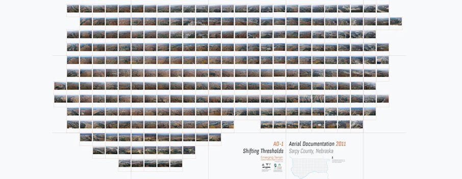
4. Aerial Photography Composite
5. History of Shadow Lake Towne Center Grid Section
Design Competition (Fall 2013 – Fall 2014)
In collaboration with the University of Nebraska-Lincoln College of Architecture, Landscape Architecture, and Community and Regional Planning, and the Rural Futures Institute, we will be assisting with a research seminar to establish the basis and brief for a national design competition to envision this suburban/rural edge of Omaha.
The competition will engage students, academics, firms, and professionals within agricultural economics, the humanities, landscape architecture, architecture, urban design, community development, business, and environmental studies. Teams will receive honorariums and be published in a forthcoming Shifting Thresholds publication. By positioning Shifting Thresholds at the intersection of a local and regional conversation, it can operate at both scales, expanding the geographic reach of its transformational potential.
Exhibitions and Publication (2014)
We have exhibited at the Sarpy County Fair the Rural Futures Conference in Lincoln, Nebraska, various locations with the Shifting Thresholds Mobile Trailer, and conducted an installation of the project as part of E.T. Talks at the empty Borders bookstore at Shadow Lake Mall. The competition results will be exhibited locally through a site-specific installation, and will travel to 6 other participating Midwest cities.
Project Partners
Sarpy County Board of Commissioners; Sarpy County Tourism; Sarpy County Historical Society and Museum; Rural Futures Initiative; University of Nebraska-Lincoln, College of Architecture, Community and Regional Planning, and Landscape Architecture.
Driving Interview Participants
Alan Linnen, Amanda Geezer, Angie and Jason Lauritsen, Ann Marie Melia Cook, Marilyn Miller, Barb Mills, Bill Kittner, Bob Dreessen, Bob Ryan, Bruce Fountain, Charles Fricke, Noah Fricke, Dan Bunch, David and Rachel Fraeling, Dean Paulsen, Deb Grayson Reinard, Dee and Keith Barkley, Denny Wilson, Dick Wardel, Ed Shaffer, Gary Garbrandt, Geoff Stewart, Matt Circo, Helen Barber, Jack Round, Jacob Landfer, Jim Miller, Josh Helig, Collin Felthacker, Lyle Johnson, Larry Gold, Loren Johnson, Lorraine Lienemann, Lowell Iske, Man on Tree Board (name withheld), Mark Scherer, Mark Wayne, Mel Hewit, Mike Mrannigan, Nick Andre, Sarah Learman, Susan Tiffani, Virginia Miller, Wendy Binegno.
Advisors and Contributors
Mark Scherer, Associate Professor, Nebraska and Great Plains Legal & Political History, University of Nebraska-Omaha; Sarah Thomas, Associate Professor of Landscape Architecture, University of Nebraska-Lincoln; Emily Andersen, Principal, DeOld Andersen Architects; Sloan Dawson, Planner, Metropolitan Area Planning Agency; David Karle, Associate Professor of Architecture, University of Nebraska-Lincoln; Brad Lubben, Agricultural Economist, University of Nebraska-Lincoln; Scott Hankins, Real Estate Specialist, Keller Williams Greater Omaha; Ben Justman, Executive Director, Sarpy County Museum; Stuart Chittenden, Public Engagement Specialist; Mark Wayne, Administrator, Sarpy County; Scott Bovick, Deputy Administrator, Sarpy County; Linda Revis, Director, Sarpy County Tourism; Drew Seyl, Master of Architecture Candidate, Harvard Graduate School of Design; David Nelson, Transportation Associate, Project for Public Places,; Anthony Campbell, PhD Candidate in Urban Studies, University of Nebraska-Omaha; Bob Trempe, Professor of Architecture, Temple University; Amy Chittenden, Community Volunteer; Tim Trumble, Public Engagement Trailer; Sarpy County GIS Department; RED Development; Jessica Pfeffer, Intern Architect, Studio Outside; Mike Henrichs, Intern Landscape Architect, Olsson and Associates.
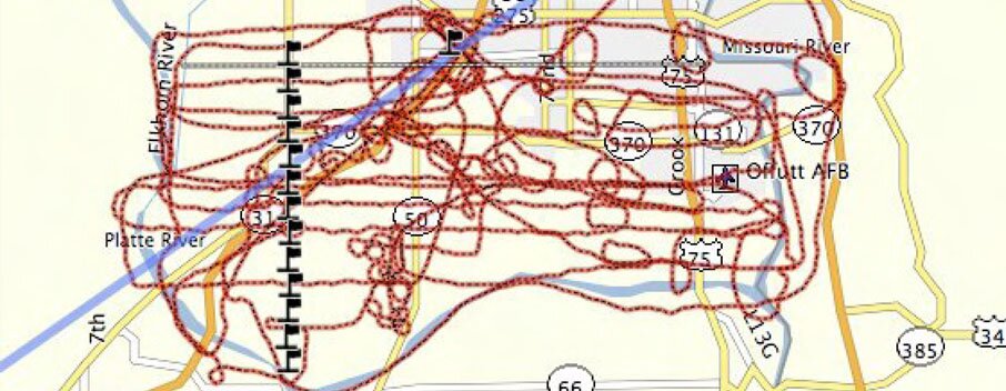
Aerial Photography by Alex MacLean
All 253 grid sections of Sarpy County were flown in September 2011. Thank you Alex, we had a stupendous time with you!
Design Fellows Team
A special thanks to 2012 Design Fellows, Sara Lum (project director), Nick Rebeck (engagement trailer and historical timeline director), and Kayla Meyer (interview and transcript director), for putting all the pieces together in an incredibly communicative way.
Sponsors
Thank you to the National Endowment for the Arts Our Town and the Nebraska Humanities Council for making the project possible.