trans:it
Transform It, Transition It, Transport It, Translate It.
Trans:it will refurbish a police truck into a mobile workshop to perform on-site redesign of major street corridors throughout Council Bluffs and Omaha. A multi-disciplinary team of Design Fellows (landscape architecture, architecture, and urban design) will spend 1 week in each of 5 different locations, applying their design skills and knowledge while collecting on-the-ground information from residents and the sites themselves; factors often not afforded through traditional client/consultant design processes. Weeks on-site will alternate with a week off-site preparing demographic data visualizations about each location, to further inform the design process and the team’s interaction with each site. The mobile workshop will focus on a different type of public space each subsequent year (streets, parks, interstate right-of-ways, etc.).
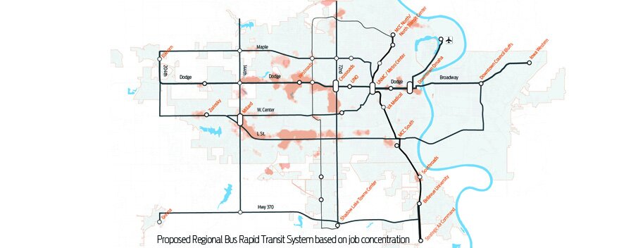
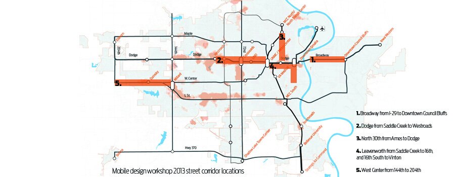
The first season will focus on corridors connected to active planning and design initiatives currently underway at other organizations and agencies throughout the metro area. Each of these initiatives are being directed by the need for a robust, regionally scaled transportation network that considers the entirety of the Omaha/Council Bluffs metro area in scope, and include formal planning processes such as: MAPA’s Regional Vision, HDR’s Central Corridor Alternatives Analysis (streetcar/BRT study), and City Planning/METRO Transportation Master Plan. We conceived of Trans:It as a way to contribute to these efforts with what we really love to do at Emerging Terrain: conduct comprehensive data directed research, engage the community within an area of consideration for additional ‘research’ only known by those living with current conditions, and utilize our skills as professional designers to assimilate the above into physical proposals for the built environment. The corridors under consideration for this first season of Trans:It include: 1) Broadway from I-29 to Downtown Council Bluffs, 2) Dodge Street from UNMC to Westroads Mall, 3) Leavenworth Street from I-480 to 16th Street and 16th Street South to Vinton, 4) North 30th Street from Ames to Dodge, and 5) West Center Road from 144th to 204th . We believe Trans:it is just one way to bridge gaps in planning processes and create innovative and meaningful public engagement, while producing tangible design proposals for consideration, all within the framework of larger planning visions.
The measurable goals of Trans:it include: creating a strategy for bridging gaps in current planning practices; designing public spaces that fall outside of current initiatives but are critically located in knitting them together; engaging community members in active design process; conducting design work on-site thus directly informed by the specifics of each place; and giving young design professionals an opportunity to stretch themselves outside of typical client/consultant contracts.
PROJECT UPDATE: We were unfortunately unable to establish the critical institutional partnerships necessary for the project to contribute to larger planning initiatives. Without these hand-in-hand collaborations, the project risks producing results that don’t integrate with larger strategies.